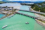
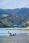
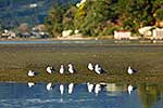
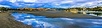
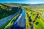
Pauatahanui Inlet (Arm) of Porirua Harbour at low tide showing mud flats. Aerial view with Moorhouse Point and Ivey Bay right, and Camborne left. Seen from Paremata, Pauatahanui Inlet, Porirua City District, Wellington Region, New Zealand (NZ), stock photo.
These images are protected by copyright, but we license them to suit your needs. Click
'quick quote' to learn more...
Pauatahanui Inlet (Arm) of Porirua Harbour at low tide showing mud flats. Aerial view with Moorhouse Point and Ivey Bay right, and Camborne left. Seen from Paremata, Pauatahanui Inlet, Porirua City District, Wellington Region, New Zealand (NZ) Stock Photo
Pauatahanui Inlet (Arm) of Porirua Harbour at low tide showing mud flats. Aerial view with Moorhouse Point and Ivey Bay right, and Camborne left. Seen from Paremata, Pauatahanui Inlet, Porirua City District, Wellington Region, New Zealand (NZ)
 of Porirua Harbour at low tide showing mud flats. Aerial view with Moorhouse Point and Ivey Bay right, and Camborne left. Seen from Paremata, Pauatahanui Inlet, Porirua City District, Wellington Region, New Zealand (NZ) stock photo.")


 of Porirua Harbour at low tide showing mud flats. Aerial view with Moorhouse Point and Ivey Bay right, and Camborne left. Seen from Paremata, Pauatahanui Inlet, Porirua City District, Wellington Region, New Zealand (NZ)")