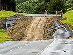
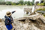
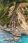
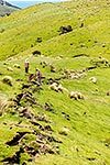
Rick King showing where his perfectly flat farmland has been pushed up over 4 metres by the Papatea Fault rupture, meaning new hills, roads and fences. Middle Hill Station. M7.8 Kaikoura earthquake, Clarence, Kaikoura District, Canterbury Region, New Zealand (NZ), stock photo.
These images are protected by copyright, but we license them to suit your needs. Click
'quick quote' to learn more...
Rick King showing where his perfectly flat farmland has been pushed up over 4 metres by the Papatea Fault rupture, meaning new hills, roads and fences. Middle Hill Station. M7.8 Kaikoura earthquake, Clarence, Kaikoura District, Canterbury Region, New Zealand (NZ) Stock Photo
Rick King showing where his perfectly flat farmland has been pushed up over 4 metres by the Papatea Fault rupture, meaning new hills, roads and fences. Middle Hill Station. M7.8 Kaikoura earthquake, Clarence, Kaikoura District, Canterbury Region, New Zealand (NZ)
 stock photo.")


")