
 stock photo.")
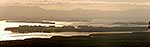
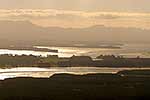
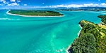
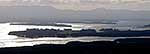
Tauranga Harbour panorama with Matakana Island foreground, Rangiwaea Is. Centre, Motuhoa Is. left, and Kaimai Ranges behind, Mount Maunganui, Tauranga District, Bay of Plenty Region, New Zealand (NZ), stock photo.
- Location:
- Mount Maunganui (other locations)
- District:
- Tauranga (see districts)
- Region:
- Bay of Plenty (see regions)
- Country:
- New Zealand (NZ)
- Notes:
- Large file (8293 x 4146 pixels native with no interpolation) | Ratio (height:width) 1:2
- Photographer:
- Rob Suisted
- Image #:
- 48964OP00
Keywords (advanced)
Related images


Similar images
Random images


")